A PROJECT BASED ON GIS (Geographic Information System)
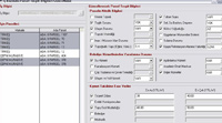
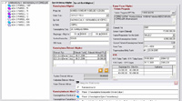
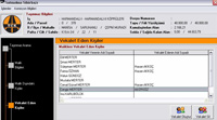
The system developed with the name Expropriation Information System by one of our solution partners Avatek, is currently used by the Highways Directorate, in some of its regional directorates. The system accelerates expropriation process, facilitates its tracking, ensures instant reporting, provides correspondence between institutions and displays the status of appropriations and payments related to the expropriation process.
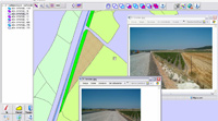
Besides, it can also perform archiving and reporting transactions related to the previously performed expropriation actions. There is one-to-one integration with the map to ensure easy tracking of expropriation operations. The system has a scalable structure to ensure control of all regional directorates from one centre. The project is one of the best examples to the application of GIS (Geographic Information System). |